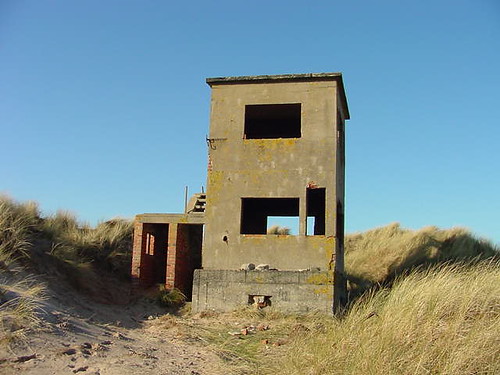
Ross Sands Bunker, Northumberland 5/8

Derelict Places

Help Support Derelict Places:

This site may earn a commission from merchant affiliate links, including eBay, Amazon, and others.

stesh

Veteran Member
Veteran Member
Joined
Feb 16, 2008
Messages
254
Reaction score
99
Location
Gateshead
Haven't got a clue what this was?

http://www.flashearth.com/?lat=55.631003&lon=-1.781821&z=19.9&r=0&src=msa

But it looks like there's two of them.

http://www.flashearth.com/?lat=55.634941&lon=-1.786525&z=19.7&r=0&src=msa

Back

31-05-08_1315.png


Side

31-05-08_1310.png


31-05-08_1311.png


Front

31-05-08_1312.png


Inside

31-05-08_1316.png


Any ideas what they are?
 
Not sure what those two structures are exactly, but there is a gunnery range up there. Plus, a number of different shaped pillboxes both in those fields and hilly bits, and on and around the beach. All with the same corrugated build.

Hope that helps a little?

:) Sal

ps heres a link to someones flickr group pics of the pillboxes.

http://www.flickr.com/photos/22829968@N04/
 
Last edited:
Unusual one, not sure :confused:

The corrugated iron shuttering suggests these were thrown up in a hurry, if that helps ...
 
You would have thought the steel would be better vertical when they were laying the concrete, sideways Id have thought it would bulge out.
Maybe it was easier that way, certaly does look unusual, but as Bob says, it was proberbly a quick job during the war :confused:
 
Just had a look at the flikr pic link that Sal provided, and the photos of the emplacements run into pics of RAF Ousten. I don't know the area, but is that nearby? That would explain the amount of defences there. Don't know what the bunkers are but it might be a decoy airfield to deflect away from the real one.
Just to muddy the waters a little... :mrgreen: ...there's what looks like a very old quarry to the south of them on the flash earth map. I was reading the other day about the use of chalk and aggregate quarries in WW2 to provide for making airfield runways, etc.
 
Crikey mate you get around! As a structure they look quite "vulnerable" in my eyes. Strong but not strong enough if you know what I mean? I am aware that just north of the Holy Island causeway they used to do target practice, especially with aeroplanes. My guessing is that these structures may have been linked to the target practice in some way. I'm afraid thats the best I can come up with!!
 
Ross bunker

Hi Guys I am new here but would like to comment on the bunker at Ross Sands. Your other correspondents are quite correct in saying that this is a relic of wartime ranges and target areas. Both Ross and Goswick to the north of Holy Island played this role in WW2 with a variety of targets for aircraft which perhaps flew from Milfield Airfield in Northumbria. In fact over the past, I think ten years the military have been engaged in clearing Goswick beach of wartime relics, not only unexploded ordnance which had a habit of showing up but the remains of the scrap vehicles used as targets. Four members of the forces were still engaged in this yesterday when I walked Goswick Sands to see the remains of two low tide shipwrecks. The military have there depot near the northmost of the two derelict observation towers associated with the Goswick Range, and from my own observations on the walk there is still a considerable amount of scrap to remove from the sands.

Blackpowder
 
Certainly very unusual constructions. I would not fancy my chances in one though, under fire that is!:(
 
Ross sands is about 40 miles from RAF Ouston. Did you see the pillbox with the 2 story range finder building on the top of it, further up the coast at Cheswick

2253407628_26e31c784d.jpg


Not my photo I hasten to add
 
On the subject of the bunker, the thing at the back looks like it was designed to hold fie, a stove? This could suggest they were inhabited for long periods of time.
Excuse my stupidity if I am wrong ;)
 

Latest posts

Back
Top