Tankervillle is one of a number of well preserved Lead mines in the Shropshire hills. It's just down the road from the better known Snailbeach. I had intended to visit the lesser known East and West Grit mines but a combination of blocked footpaths and large scary farm animals caused me to abandon my quest in favour of something safer.
Tankerville's shaft was the deepest in the Shropshire orefield at 1,690ft and was vertical for a short distance before descending at an angle. Although it was mainly worked for lead, it also produced barytes, calcite, silver and zinc during its working life between 1865-1925.
The obvious large building is the Engine House, which housed a 40” pumping engine for the mine. Next to this is an octagonal chimney which served the boiler house. There are a number of other relics in the vicinity, including a couple of collapsed shafts (lots of danger signs).
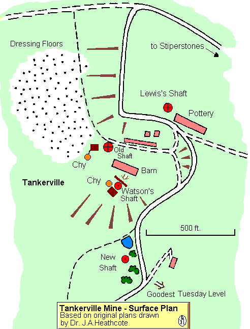
map of the mine and associated buildings
Engine House

Chimney

General view of the site including ore bins (left) and Heath Robinson winding gear

View down the shaft

Whilst in the vicinity I had a quick look at two other mines.
The delightfully named Bog Mine, and Shelve Mine
Bog was once whole village, with school. houses and a Miners institute. Not much left now, a tunnel, the old powder house and the school converted to a visitor centre

Somme Tunnel - Bog Mine

Powder House

Shelve Mine - Engine House

Mountings for Winding gear?

Very very deep channel

There is a really excellent web site created by the Shropshire Mines Trust which gives the location of all the mines and a description of the surface remains
http://shropshiremines.org.uk/
Tankerville's shaft was the deepest in the Shropshire orefield at 1,690ft and was vertical for a short distance before descending at an angle. Although it was mainly worked for lead, it also produced barytes, calcite, silver and zinc during its working life between 1865-1925.
The obvious large building is the Engine House, which housed a 40” pumping engine for the mine. Next to this is an octagonal chimney which served the boiler house. There are a number of other relics in the vicinity, including a couple of collapsed shafts (lots of danger signs).
map of the mine and associated buildings
Engine House
Chimney
General view of the site including ore bins (left) and Heath Robinson winding gear
View down the shaft
Whilst in the vicinity I had a quick look at two other mines.
The delightfully named Bog Mine, and Shelve Mine
Bog was once whole village, with school. houses and a Miners institute. Not much left now, a tunnel, the old powder house and the school converted to a visitor centre
Somme Tunnel - Bog Mine
Powder House
Shelve Mine - Engine House
Mountings for Winding gear?
Very very deep channel
There is a really excellent web site created by the Shropshire Mines Trust which gives the location of all the mines and a description of the surface remains
http://shropshiremines.org.uk/
")